Most visitors only see Sayulita's main beach, with its surf schools and colorful umbrellas. But within walking distance there's a lot more: a sheltered cove you reach by passing through a cemetery, a wild dark-sand beach with heavy surf, and quiet coves tucked into the jungle. Here's what each Sayulita beach is like, how to walk there, the history behind this stretch of coast, the wildlife you might spot in each season, and how to stay safe in the water.
A Short History of the Sayulita Coast
Long before the surf shops, this coastline belonged to haciendas, coconut groves and fishermen. The municipal chronicle of Bahía de Banderas links Sayulita to a place called Santa Cruz Saloc, mentioned in the Relación de Compostela of 1584, and a 1798 map of the coast of Nueva Galicia still labels it "Santa Cruz." By then the area was part of the Jaltemba hacienda, an estate that, according to the same chronicle, ran along the coast from Punta de Mita to La Peñita.
The town's current name came much later. The most widely told version credits the hacienda's manager, Lauro González Guerra, who around 1920 named the village after his hometown of Sayula, Jalisco. "Sayulita" simply means "little Sayula."
Back then the beaches were workplaces. Early residents gathered the small nuts of a native palm to press for oil, and fished on the side. One detail ties directly to the beaches in this guide: according to family memories published by the local paper El Sayulero in 2008, the original community lived at Pátzcuaro, a few miles south, before settling around today's bay. Sayulita's ejido (communal land grant) was formed in 1936, and when coconut production collapsed in the 1940s, fishing and farming took over. The pangas you see pulled up on the main beach today carry on that trade.
Everything changed with the Las Varas–Puerto Vallarta highway in 1965 and the traveling surfers who began showing up in the 1960s, drawn by consistent waves. For the full story of the town, see our guide to things to do in Sayulita.
Sayulita Coast Timeline
- 1584: The Relación de Compostela mentions Santa Cruz Saloc, which the municipal chronicle identifies as Sayulita.
- 1798: A map of the Nueva Galicia coast shows it as "Santa Cruz," within the Jaltemba hacienda.
- Around 1920: The village gets the name Sayulita.
- 1930s: Families arrive to gather coconuts for the hacienda.
- 1936: The Sayulita ejido is formed.
- 1940s: Coconut production falls; fishing takes over.
- 1960s: The first surfers arrive.
- 1965: The Las Varas–Puerto Vallarta highway opens.
- December 2015: Sayulita is named a Pueblo Mágico ("Magic Town").
- 2024: Mexico decrees the Sierra de Vallejo–Río Ameca Biosphere Reserve, which covers part of the Bahía de Banderas municipality.
Sayulita Main Beach
The town beach sits right in front of downtown and is where the surf schools set up. Waves roll in almost year-round, so beginners, experienced surfers and swimmers all share the water. The best-known wave breaks near the river mouth, while beginners usually practice in front of the fishing boats. For more on lessons and breaks, see our guide to surfing in Sayulita.
If you want to swim, local guides suggest staying toward the south end of the beach, away from the river mouth and the main surf break. Rip currents do form on the main beach, especially when the surf is up. Mornings are usually calmest; wind and surf tend to pick up around midday.
A tip for photographers: in the rainy season the sun sets farther north and you can watch it straight from the main beach. In the dry season, head to the beaches south of town.
Playa de los Muertos, Sayulita
Playa de los Muertos ("Beach of the Dead") is a small cove just south of town, tucked between big rocks on both sides, with gentle waves and little current. That makes it a favorite with Mexican families and one of the best Sayulita beaches for kids. There's no boat traffic or surfing, and a swimming area is sometimes roped off.
Why the name? The path to the beach passes the town cemetery, which sits on a small hill above the sea, and the beach name is associated with it. The graves are lovingly decorated with flowers, candles and photos, so walk through quietly and respectfully, and stay on the path. Don't confuse it with Puerto Vallarta's Playa de los Muertos, the big city beach in the Romantic Zone.
The cemetery on Day of the Dead. From October 31 to November 2, Sayulita honors its dead with altars in the plaza, catrina face paint and a nighttime procession to the cemetery, which fills with flowers and candles. The town's community altar is fairly young: according to El Sayulero, it started around 2008 with a small group of neighbors and seven altars, and in 2018 it was dedicated for the first time to local fishermen lost at sea. It's a family occasion, so ask before taking photos.
How to get there: from the main beach, follow the shore south and take the dirt road that climbs toward the cemetery. Walk under the entrance arch, through the cemetery, and down the other side of the hill to the beach. It's about a 10-minute walk from downtown, and there is no entrance fee.
Just past the rocks there's an even smaller cove called Las Cargadas. Only try to reach it when the tide and waves allow.
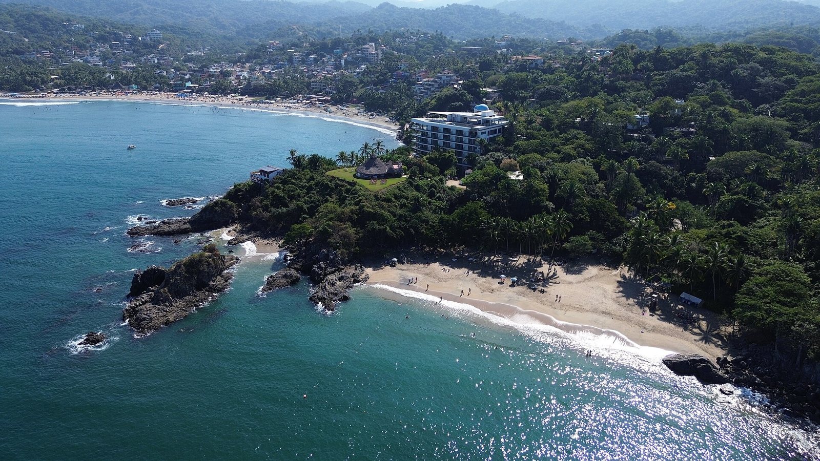 Playa de los Muertos, the sheltered cove just south of town.
Playa Carricitos: Dark Sand and Big Waves
Playa Carricitos lies farther south, past the turnoff for Los Muertos. It's a more open, wild beach with dark sand, formed by eroded volcanic rock, with homes hidden in the wooded hills above. It's usually far less crowded than town.
How to get there: it's a jungle walk with some ups and downs. Guides estimate 30 to 40 minutes from the main plaza, following Calle Niños Héroes and then a trail into the jungle; take the left fork, and finish with a short set of steps down to the sand. The trail can get muddy in the rainy season.
Important: the waves at Carricitos are often big and the undertow is strong. This is not a swimming beach, and definitely not for kids. Come for a beach walk, photos, a dry-season sunset or, if you're experienced, some bodyboarding or bodysurfing. There are no services, so bring water, snacks and sunscreen.
More Beaches Near Sayulita
- Playa Las Cuevas and Playa Malpaso (north). About 2 miles from town, framed by rocky cliffs, with light sand and clear water. A jungle trail splits toward Las Cuevas, the first small cove, and over the hill to Malpaso; at low tide you can also pass through a natural rock arch. There are reports of construction and private land along the route, so ask locally about access before you go, and watch the tide so you don't get cut off on the way back. It's a quiet rainy-season sunset spot.
- Playa Patzcuaro and Patzcuarito (south). Quieter and more remote, with no vendors or facilities; reached by roughly an hour's hike, or a 10-minute drive toward Punta Mita plus a walk. Patzcuarito has dark sand and, according to local guides, it's the best sunset spot from late fall to early spring, when the sun drops behind the hills of Punta Sayulita. Waves can get heavy when there's a swell. Local memory places Sayulita's first settlement here.
- San Pancho. A few minutes north of Sayulita, with a long beach and a more laid-back vibe. Read our San Pancho beach guide.
Want to explore beyond Sayulita? Check out our guide to Riviera Nayarit beach towns, or head south to Punta Mita.
Wildlife on Sayulita's Beaches
Between the open Pacific and the dry tropical forest on the hills, you'll find coatis, armadillos, iguanas, chachalacas and deer. In 2024 Mexico's federal government decreed the Sierra de Vallejo–Río Ameca Biosphere Reserve, roughly 225,000 hectares (about 556,000 acres) across Jalisco and Nayarit, including part of the Bahía de Banderas municipality.
- Sea turtles. Olive ridleys are the species that nests most often on Sayulita's beaches, with an occasional leatherback. Nesting runs roughly from June to December, busiest from September to December. A local volunteer turtle camp moves nests to a protected hatchery and often releases hatchlings at sunset. If you see a marked nest, leave it alone. Our guide to sea turtles in Riviera Nayarit covers the rules.
- Humpback whales. They pass this coast in winter. The official 2025–2026 whale-watching season in Banderas Bay ran from December 8 to March 23, and you can sometimes spot blows from shore, especially from the north end of the beach early in the morning. Bring binoculars. More in our whale watching guide.
- Dolphins. Seen year-round, sometimes just beyond the surf.
- Stingrays, jellyfish and urchins. Stingrays show up in warmer months, so shuffle your feet when you walk in. Jellyfish appear as the water warms in spring, and sea urchins cling to the rocks at the main surf break.
When to Visit Sayulita Beaches
- Dry season (roughly November to May): clear skies, cleaner water and the best time for the hikes to Carricitos and Malpaso. It's high season, and it overlaps with whale season. Using Puerto Vallarta as a reference, the water is around 75°F (24°C) from January to March.
- Rainy season (roughly June to October): heat, humidity and quick tropical downpours. The water reaches about 86°F (30°C), trails get muddy, mosquitoes are out, and it's turtle season. After heavy rain, the river turns the main beach murky.
The sun is strong all year: seek shade between 11 a.m. and 3 p.m.
Beach Safety in Sayulita: Waves, Rip Currents and Flags
- Check the flags. Mexico has no single mandatory national system, but most beaches use the same basics: green means good conditions, yellow means use caution, red means stay out of the water, and purple warns of dangerous marine life such as jellyfish or stingrays. If you see a red flag, don't swim.
- Rip currents. If a current pulls you out, don't fight it. Stay calm and swim parallel to the shore until you're out of it.
- Don't count on lifeguards everywhere. Remote beaches like Carricitos and Malpaso usually have no lifeguard on duty.
- On the trails, bring water, bug spray and closed-toe shoes. Tell someone where you're going and head back before dark.
Ocean conditions change daily, so check current conditions with lifeguards or locals before you get in the water.
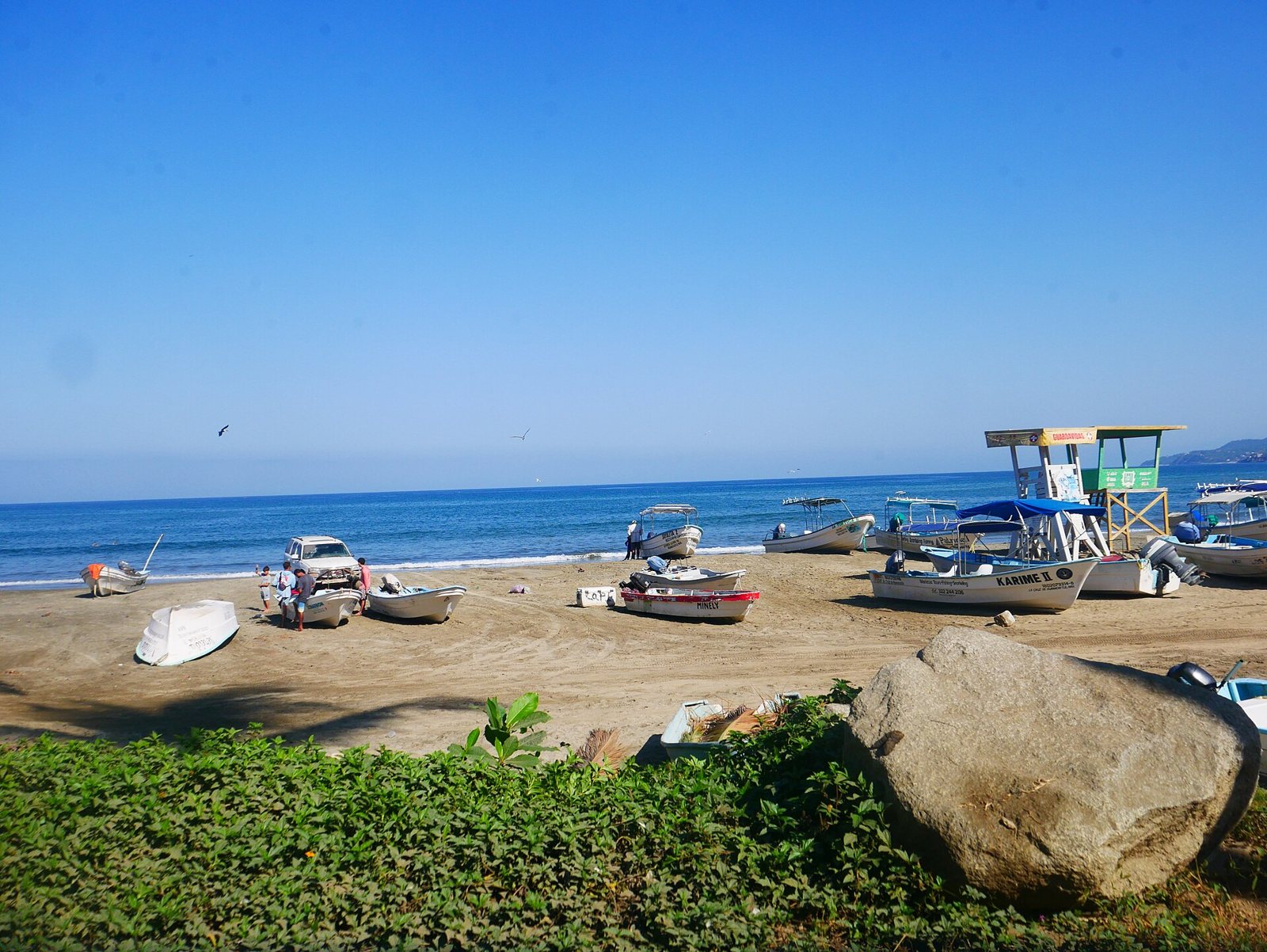 Boats and a lifeguard tower on Sayulita beach.
Is Sayulita Beach Safe to Swim? Water Quality
COFEPRIS, Mexico's federal health-risk agency, tests popular beaches with state health authorities before each vacation period and publishes the results. In its first round of testing in 2025, before Easter week (released in April 2025), Sayulita's beach was one of six in the country that exceeded the limit for fecal enterococci for recreational use.
According to local reporting, on April 15, 2025 the mayor of Bahía de Banderas announced the beach was safe for swimming again, after a sewage spill and a loose discharge pipe at the treatment plant were fixed. The local nonprofit ProSayulita also ran its own tests with an accredited lab and reached the same conclusion. The town has been upgrading its sewage system in phases since 2017, including the outfall near the river.
In the more recent reports we reviewed, Sayulita is no longer on the list of beaches flagged as unsuitable: not for the 2025 winter holidays, Easter 2026 or summer 2026 (July 2026). Results can change from one season to the next and tend to get worse after heavy rain; Playa de los Muertos, far from the river, is less affected. Check the latest COFEPRIS report before your trip, and after a big storm give it a couple of days before swimming near the river mouth.
Suggested Sayulita Beach Itinerary
Half day: hit the main beach early for a swim (or a surf lesson) while the water is calm. Mid-morning, walk south through the cemetery and settle in at Playa de los Muertos until it gets busy around noon.
Full day: hike to Carricitos early, before the heat. Head back to Los Muertos for a calm swim, have lunch in town and spend the afternoon on the main beach. In the dry season, if you have a car, end with sunset at Patzcuarito.
What to pack: plenty of water, biodegradable sunscreen, a hat, bug spray, sneakers for the trails, a bag for your trash and cash. Budget: the beaches are public and free; your costs come from food, umbrella or board rentals and surf lessons.
Etiquette: be respectful in the cemetery, pack out your trash and leave turtle nests alone.
Visit Sayulita with Riviera Tours & Transfers
If you'd rather not drive, our Sayulita and San Pancho tour runs Tuesday, Thursday and Saturday. It's a full-day tour offered in English and Spanish, in small groups of up to 17 people, and it includes:
- Round-trip transportation
- Certified tour guide
- Tasting of traditional Mexican sweets
- Visit to San Pancho's main square and beach
- Guided walking tour of downtown Sayulita
- Free time in Sayulita (you can spend it on the main beach)
- 1–2 bottles of water
Optional: surf lessons at an extra cost, with a 50% discount for tour guests. Food is not included. The tour does not hike to Carricitos or Malpaso; those beaches are best visited on your own.
See dates and book the Sayulita and San Pancho tour →
Tips for Your Beach Day
- Bring cash for small stands and crafts.
- Use reef-safe, biodegradable sunscreen and pack a towel.
- Go early to Los Muertos: it's small and fills up by midday.
- Check the tide before heading to Malpaso or the coves next to Los Muertos.
- For the trails, wear sneakers or hiking sandals, not flip-flops.
- Planning the rest of your day? Read our list of things to do in Sayulita and our Sayulita food guide.
FAQ
What is the best beach in Sayulita for swimming? Playa de los Muertos, a sheltered cove with small waves. Still, check the flag and keep an eye on kids.
Can you swim at Playa Carricitos? It's not recommended. Waves are often big and the undertow is strong. It's better for walking, photos and sunsets.
How do you get to Playa de los Muertos in Sayulita? Walk about 10 minutes south from downtown along the dirt road that passes the town cemetery. There's no entrance fee.
Why is it called Playa de los Muertos? Because the path to the beach runs through the town cemetery on the hill above the sea. We found no documented origin for the name beyond that.
Is Sayulita beach safe to swim in? COFEPRIS flagged it as unsuitable before Easter 2025, but it hasn't appeared on the unsuitable lists for the 2025 winter holidays or 2026. Check the latest official report, and always follow the flags.
Can you see sea turtles or whales from the beach? Depending on the season. Turtles nest roughly from June to December, and humpbacks pass in winter; with binoculars you can sometimes see them from shore.
When is the best time to visit Sayulita's beaches? November to May brings less rain, cleaner water and dry trails. Summer is quieter, but hotter, wetter and buggier.
Does the Riviera TT tour go to Carricitos or Los Muertos? No. It includes a guided walk through downtown and free time in Sayulita; the remote beaches are a do-it-yourself trip.
Photos: Luisalvaz / CC0 via Wikimedia Commons · Luisalvaz / CC0 via Wikimedia Commons · Luisalvaz / CC BY-SA 4.0 via Wikimedia Commons