Just up the coast from Sayulita, the small town of San Francisco, better known as San Pancho, has one of the most relaxed beaches in the Riviera Nayarit. It is wide, open to the Pacific and backed by jungle-covered hills, and it feels a world away from the busier beach towns nearby.
There is also a surprising story behind the sand. San Pancho has been a fishing village, part of a colonial coconut-oil hacienda, the showcase of a 1970s presidential experiment and, today, one of the most community-minded towns on this coast. Here is what to know about San Pancho Beach before you go: what the ocean is like, when to surf, when to visit, and where everything you'll see came from.
What San Pancho Beach Is Like
San Pancho Beach stretches for roughly 1.5 km (about a mile) at the foot of the Sierra de Vallejo mountains. The sand is soft and the beach is broad, with the town's main street running right down to it, so you can walk from the village straight onto the sand.
The town sits only about 13 meters (40 feet) above sea level, squeezed between the Pacific and the mountains, with Lo de Marcos to the northeast and Sayulita to the southwest. A seasonal river, the Río Los Izotes, runs along the edge of town and only carries water in the rainy season.
San Pancho belongs to the municipality of Bahía de Banderas, along with Sayulita, Bucerías and Punta de Mita. Handy tip: this municipality runs on Central Time, the same as Puerto Vallarta, so you won't need to change your watch. It is about 50 km (30 miles) north of Puerto Vallarta on Federal Highway 200.
The town is tiny. Mexico's 2020 census counted just over 1,400 residents (back in 1970 there were fewer than 400), and that small-town feel carries over to the beach, which usually feels much less crowded than Sayulita's, even in high season.
San Pancho History: From Apazan to Beach Town
Fishermen, Pearls and Coconut Oil
Before the Spanish arrived, this coast and the nearby mountains were home to Indigenous peoples such as the Cora and the Huichol (Wixárika). According to early colonial records, in 1524 the explorer Francisco Cortés de Buenaventura called the place Apazan (some sources spell it Azapan), a settlement made up mostly of fishing families.
A 16th-century survey of New Galicia's towns, the Suma de visita, lists Apazan with 229 married men and places it 14 leagues from Compostela. Along with neighbors such as Santa Cruz Saloc, the forerunner of today's Sayulita, its people harvested and traded dye snails, shells and pearls.
The village later became San Francisco de Apazan and was folded into the Hacienda de Jaltemba, which produced coconut oil. And since every Francisco in Mexico gets called "Pancho," the town ended up as San Pancho.
The Ejido and the Echeverría Years
In the 1930s, under Mexico's land reform, the land around Sayulita and San Francisco became communal ejido land (sources disagree on the exact year, 1931 or 1936). Until the 1970s, locals lived on fishing, mangoes and other tropical fruit.
Then came President Luis Echeverría (1970–1976), who, according to several sources, used San Pancho as a family retreat. In 1972 the government created the Bahía de Banderas Ejido Union, a pilot project joining eight local ejidos, and Highway 200 opened around the same time. San Francisco became the hub of the plan: cobbled streets, drainage, electricity, a hotel school, a marine technology center, a clinic-hospital and a CONASUPO agro-industrial complex that processed dairy, canned goods, coconut oil and seafood. There was even a short-lived "Third World University."
You can still see that era today. The main avenue is called Avenida Tercer Mundo ("Third World Avenue"), several streets are named after faraway places such as Africa, India and Egypt, and the regional IMSS hospital is a legacy of the plan.
From Ruins to "Cultural Capital"
By about 1988, nearly everything except the hospital had been dismantled, and the big warehouses sat empty for years. In 1989 the town moved from the municipality of Compostela to the newly created Bahía de Banderas. A 1992 reform allowed ejido land to be sold, and buyers began arriving, many from the U.S. and Canada. A 1996 Seattle Times travel piece described a town of about 1,500 people with little tourism, a ruined cannery and a turtle hatchery run by locals.
From the mid-2000s, the old warehouses became a home for artists and community projects, and San Pancho now bills itself as the "cultural capital" of the Riviera Nayarit. Read more in our guide to San Pancho's circus and culture.
San Pancho Timeline
- 1524: Francisco Cortés de Buenaventura records the fishing village of Apazan.
- Colonial era: San Francisco de Apazan becomes part of the Hacienda de Jaltemba (coconut oil).
- 1930s: The land becomes communal ejido land.
- 1972: The Bahía de Banderas Ejido Union is created; Highway 200 opens around this time.
- 1970s: Echeverría's plan brings the hospital and the CONASUPO complex.
- c. 1988: The complex is dismantled; the hospital stays.
- 1989: San Francisco moves from Compostela to Bahía de Banderas.
- 1992: Land reform; the Grupo Ecológico de la Costa Verde starts the area's first turtle hatchery.
- 2006: Entreamigos is founded; the warehouses become artist spaces.
- 2011: The Circo de los Niños de San Pancho is born.
- 2024: The Sierra de Vallejo–Río Ameca Biosphere Reserve is decreed.
Swimming at San Pancho Beach: Waves and Safety
The most important thing to know is that San Pancho Beach faces the open ocean. It is not sheltered by Banderas Bay, and the surf can be powerful, with heavy shore break and rip currents. Several local guides agree that the south end of the beach usually has the calmest water and is the best spot for a swim.
A few common-sense rules:
- Watch the water for a few minutes before going in. A rip current often looks like a channel of churning or differently colored water, a line of foam moving out to sea, or a gap where waves aren't breaking (careful: that gap can look like the "calmest" spot).
- Follow any warning flags and instructions from lifeguards or Civil Protection, if they are posted that day.
- Don't swim alone, keep a close eye on kids and stay well away from where people are surfing.
- If you get caught in a rip, don't fight it. Swim parallel to the shore until you are out of the current, then angle back in. If you can't, float and wave for help.
Conditions change with the season and from day to day, so always check the ocean on the spot.
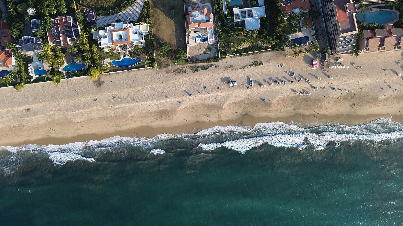 Waves along San Pancho beach, seen from above.
Surfing in San Pancho
San Pancho has a solid reputation with surfers, but it is not a beginner break. Waves break over a mix of sand, rock and reef, and surf guides recommend it for intermediate and advanced surfers. There are really two setups:
- The point at the south end: a left that peels off the rocky headland. It works best on big summer swells and tends to close out in winter.
- The beach break near the river mouth: fast and sometimes hollow, with strong rips and patches of sharp coral that are exposed at low tide. It closes out easily on big days.
Surf guides agree that summer and early fall bring the best waves, with southwest swells; October is often named the most consistent month. The ideal wind is offshore, from the east. The water is warm, so a rash guard or a 2 mm spring suit is enough most of the year.
If you are just learning, Sayulita is a much friendlier place to start; see our guide to surfing in Sayulita. Experienced surfers can find board rentals in town.
Sunsets on San Pancho Beach
The beach faces west and northwest, with nothing between the sand and the horizon, so the sun drops straight into the Pacific. People gather on the sand, surfers catch the last waves of the day and the sky turns orange and pink. If your schedule allows, plan to stay until the sun goes down.
Sunset time shifts quite a bit between winter and summer, so look it up for the day of your visit and get there with half an hour to spare.
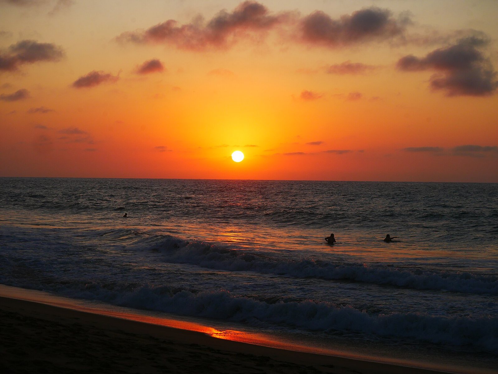 Sunset at San Pancho beach.
Weather and the Best Time to Visit San Pancho Beach
San Pancho has a warm, semi-humid climate. January averages about 22 °C (72 °F) and July about 28.5 °C (83 °F). The big difference is rain: April is practically dry (around 2 mm for the month), while August gets more than 340 mm (over 13 inches). That makes for two very different seasons:
- November to April (dry season): clear skies, less humidity and peak visitor season. It overlaps with humpback whale season in Banderas Bay, December to March (see our whale watching in Puerto Vallarta guide).
- June to October (rainy season): hotter, with lush green jungle, sea turtle season and the best waves for experienced surfers.
Nature: The Jungle Behind the Beach
The Sierra de Vallejo rises right behind town, and since January 2024 it has been part of the Sierra de Vallejo–Río Ameca Biosphere Reserve, a protected area of more than 225,000 hectares (about 557,000 acres) across Jalisco and Nayarit. Alianza Jaguar, a conservation group born in San Pancho, worked for roughly 20 years to make the reserve happen.
Mexico's biodiversity commission, CONABIO, considers this forest a conservation priority. It is home to jaguars and many other mammals, reptiles and amphibians. A 2016 study recorded more than 40 local bird species, and since 2014 the town has had the San Pancho Bird Observatory, which grew out of a 2007–2009 school birding club designed to steer kids away from hunting birds and toward protecting them. Bring binoculars in the morning.
Sea Turtles in San Pancho
The Grupo Ecológico de la Costa Verde, a volunteer group founded in 1992 by Frank Smith and Elvia García, ran the area's first turtle hatchery and protects nests on this beach, mostly olive ridley turtles. During the season, volunteers patrol the beach at night and move eggs to a protected nursery.
On Mexico's Pacific coast, nesting peaks from May to September. Since incubation lasts six to eight weeks, hatchlings typically emerge and are released from about July to November, according to Mexico's environmental agency, Semarnat. Every sea turtle species in Mexico is listed as endangered under the official standard NOM-059.
Good to know:
- Only authorized staff and certified volunteers may handle turtles, eggs or hatchlings. Disturbing or taking eggs is a federal crime in Mexico.
- If you see a turtle nesting, keep your distance (about 10 meters / 30 feet), skip the flash and white flashlights, and let the conservation group know.
- Public hatchling releases vary from season to season, so check directly with the group before planning around one.
For more places to see turtles, read our guide to sea turtles in the Riviera Nayarit.
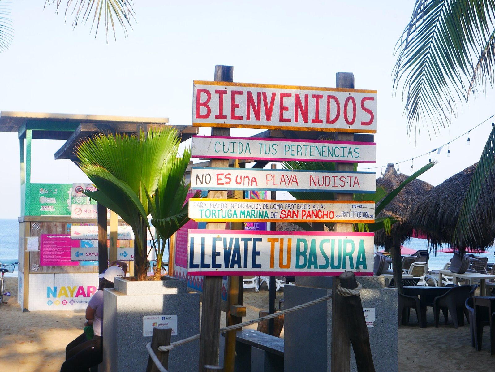 Welcome sign at San Pancho beach, with reminders to protect sea turtles and take your trash home.
Local Culture: Fiestas, Art and Food
The patron saint festival. San Pancho honors Saint Francis of Assisi with a nine-day fiesta that ends on October 4. Each night a different neighborhood leads a candlelit procession with floats and costumes to the church, and the plaza fills with food and music. Expect "el torito" (a runner wearing a frame of skyrockets), a torch relay from a nearby town, rodeos and, at midnight on the last day, the "castillo" fireworks tower. Check the program for the current year.
Art on the streets. You'll find murals by local and visiting artists, galleries and crafts, including work by the Huichol community that lives in town (see our Huichol art guide).
Entreamigos. This community center started in 2006 as a small arts-and-crafts project for local kids and now operates out of a former creamery, with a library, workshops and a recycling program. Visitors can stop by or ask about volunteering.
Circus and polo. In 2011, Cirque du Soleil co-founder Gilles Ste-Croix helped launch the Circo de los Niños de San Pancho, which trains local kids in the performing arts. On the edge of town there is also a polo club with seasonal matches; read about it in polo in San Pancho.
Flavors of the coast. Nayarit's signature dish is pescado zarandeado, a whole fish grilled over coals, whose origin is traced to the island of Mexcaltitán. Learn its story in our pescado zarandeado guide.
For the full picture of the town, read our San Pancho, Mexico guide. Comparing beaches? Check out Sayulita's beaches and our roundup of Riviera Nayarit beach towns.
A Sample Day in San Pancho
Half day: arrive mid-morning, walk the beach end to end, watch the surfers from the sand, take a dip at the south end if the ocean allows, and finish with a stroll around the plaza and the murals.
Full day (on your own): birding or a surf session early, breakfast in town, beach time and a rest during the hottest hours, the plaza, galleries and Entreamigos in the afternoon, and back on the sand for sunset.
Visit San Pancho Beach with Riviera Tours & Transfers
Want to see San Pancho and Sayulita in one day without driving? Our Sayulita & San Pancho tour runs Tuesday, Thursday and Saturday. It is a full-day tour in English and Spanish, with a maximum of 17 guests, and it includes:
- Round-trip transportation
- Certified tour guide
- Tasting of traditional Mexican sweets
- Visit to San Pancho's town plaza and beach
- Guided walking tour of downtown Sayulita
- Free time in Sayulita
- 1 to 2 bottles of water
Lunch is not included. Optional surf lessons are available at an extra cost, with a 50% discount for tour guests.
See dates and book the Sayulita & San Pancho tour →
Tips for Visiting San Pancho
- Bring cash. It's a small town, and not every business takes cards.
- Pack reef-safe sunscreen, a hat and water. There is little natural shade on the sand.
- Wear comfortable shoes for town and bring bug spray in the rainy season.
- Time your day for sunset if you are visiting on your own.
- Budget: there are no big resorts; guesthouses, hostels, small eateries and bakeries are the norm, so your day can be as simple as you like.
- Respect the beach and the town: pack out your trash, stay clear of marked turtle nests and ask before photographing people.
FAQ
Is San Pancho Beach safe for swimming? It can be, with caution. It is open ocean, and waves and currents can be strong. The south end is usually calmer. Check conditions and any posted flags before you go in.
Is San Pancho good for beginner surfers? Not really. The waves are heavier and break over rock and reef. Beginners will have a better time in Sayulita.
When is the best time to visit San Pancho? November to April for dry, sunny beach days and sunsets. June to October is hotter and rainy, but it brings turtles, green jungle and bigger surf.
When can you see sea turtles in San Pancho? The nesting and hatching season in the region runs roughly from July to November. Public releases are not guaranteed, so confirm with the local conservation group.
Why is it called San Pancho? The official name is San Francisco, after its patron saint, Saint Francis of Assisi. "Pancho" is the traditional Mexican nickname for Francisco.
How far is San Pancho from Sayulita and Puerto Vallarta? About 5 km (3 miles) north of Sayulita and about 50 km (30 miles) north of Puerto Vallarta on Highway 200.
Does the Riviera tour stop at San Pancho Beach? Yes. The Sayulita & San Pancho tour includes a visit to San Pancho's plaza and beach, plus free time in Sayulita.
Photos: Luisalvaz / CC0 via Wikimedia Commons · Luisalvaz / CC0 via Wikimedia Commons · Luisalvaz / CC BY-SA 4.0 via Wikimedia Commons · Luisalvaz / CC BY-SA 4.0 via Wikimedia Commons